
I had a very good time on the Gran Senda de Málaga but there were some difficulties, too. These were because I had some unfulfilled expectations on what would or wouldn’t happen. I hope I can help future hikers to know a little bit more about this wonderful trail than I did while planning and hiking.
What I did:
My original plan was to trough-hike the western part of the trail from Nerja until the end of my two weeks holidays. But the unmerciful heat and my therefore blistered feet made me jump the big stages and only do the small ones and to finally give up the idea of a through-hike. The result was that hiked a sample of nearly every possible landscape of the Gran Senda de Málaga and some other famous trails in Andalusia.

I did one stage starting in Nerja in the Sierra de Tejeda, two stages in the gradually decreasing Sierra, starting from Periana and from Pulgarin Alto, I had to rest my feet for two days in Antequera, sent home my shoes and bought new ones, then I continued in the very flat and dry northern area of the trail starting from Alameda to continue the next day from Fuente de Piedras. This part of the trail was so f…g hot and therefore so exhausting that decided to do day hikes with only water in my pack. I stood four nights on the wonderful Camping Parque Ardales and did the stage Ardales-El Chorro, the Sendero Gaitanejo and the famous Caminito del Rey from there. Than I went on to Cartajima in the South of Ronda to do a hike to Los Riscos and one to the white villages of the Valley of Genal. My last day I sat on the roof terrace of the wonderful Refugio Hostel and did nothing but looking the swallows whizzing through the blue sky.
Facts about the Gran Senda de Malaga:
Location: Andalusia in southern Spain
Length: 656 km
Potential dangers: Hunting, some road walks, breeding boars, wasps, dogs, getting lost, no water, river crossings in the colder seasons, eventual forest fires.
Difficulty: There are very easy stages and very long and/or difficult mountain stages. To predict the difficulty of every stage there is a very useful table provided by the Gran Senda Organisation. Also you will find the composition of paths (single trail, dirt road, road, river crossing) at the beginning of every description of the stages in the downloadable guidebook provided in english language.
Civilisation density: You will have at least one point of civilization on or at the end of every stage. This doesn’t mean that you’ll find accommodation or something like a pharmacy over there. But at least there will be a bar and a cold cerveza.
Landscape: Very diverse and very beautiful, sometimes unbelievably lovely. You’ll see the Mediteranean Sea, the mountains, agricultural landscapes, lakes and hills. A very good reason to do it! I was completely overwhelmed.
Cultural sites: You will cross some “bigger” cities with wonderful cultural sites like Ronda, Archidona, Nerja and Malaga. But in general the trail passes through simpler, rural areas.
Best time to do it: There is one thing I can already say: Do it in May, but in the beginning of May. It’s the time of bloom, the landscape buzzes and you’ll see the most fantastic colors around you. But in this year it was a particularly hot May and there is not a lot of shadow on the road. It can be hell, too. Maybe it’s better to do it in autumn or even winter. But you won’t experience the wonders of spring then. Look at the climate table of Andalusia and see what suits you most.
Trail signage and way markers:
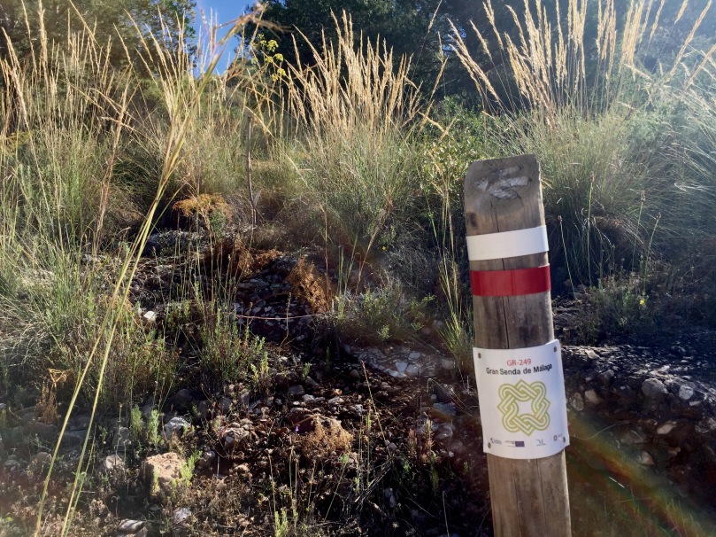
If there is one compliment to be given to the Gran Senda Organisation then it is that one: The signage is nearly perfect. Everywhere, even in the most lost areas, you’ll find wooden posts with striped (go!) or crossed (don’t go!) trail marks. You wont get lost if you hike with your eyes open. As I hiked in the end of May and nature was in full bloom it happened that one or two posts were hidden behind bushes, but in general they were easy to locate. There were only two times when I had some difficulties finding my way. On the stretch from Nerja to Frigiliana behind the river crossing I lost one hour because of bad signage and in the forest from Ardales to El Chorro I saw a “corzo morisco”, a kind of a mountain deer, directly in front of me and out of surprise I missed the junction which was well hidden in some bushes.
Sometimes I had the impression that someone coming from the opposite direction has installed the trailmarks.
Busyness and Solitude:

Between Nerja and Frigiliana I briefly met two girls from Switzerland who did more than one stage. I also met some day hikers on this stage. Between Periana and Pulgarin Alto I met a group of American day hikers on a visit to Andalusia again. That was it. This trail is – regarding other hikers – completely deserted. You’ll meet forest workers, farmers and some tourists in cars when the road is near, but there aren’t any hikers. At least in the areas where I was. It’s quite a lot of solitude to take in. You either search for that or you have to deal with it when you are hiking solo.
Documentation:

There is this great guide which you can download for free on the website of the trail. There is some really good information in it, like the lengths the heights and the level of difficulty of every stage after which I chose the stages I wanted to walk. If you are interested in it there is even some quite useful information about history and geography. Unfortunately it also lacks some really important information.
- Maps.
The maps they provide in the guide and on the website by the Gran Senda Organisation are completely useless. Don’t even bother to load them down or print them out. I recommend some kind of App with offline Maps based on Openstreetmap (for example MapOut for IOS). Offline Maps are – in my opinion – mandatory. - Water.
There is no real indication about where and when to find water on the trail or even the possibility of water. As I walked in the month of May at an shadowless average of 27°C I would have been very grateful not to have to pack 3 liters of water on top of the weight of my backpack. In the guide they write about water but more generally, where it comes from and why and the geological conditions. In case you are sweating like I did, this is quite useless. - GPS Downloads.
There are GPS downloads of every single stage and they are obviously very detailed. I don’t know what I did wrong but I wasn’t able to load them into my map app (MapOut). There is no download of the complete trail. At least I didn’t find it. Instead I downloaded it from gpsies.com. But this was clearly not always the designated trail (read this, if you want to walk Nerja-Frigiliana). - Accommodation and transport.
There is no useful information about the end of every stage. If there is civilization, accommodation, something to eat and drink or private or public transport. All things you are longing for after an exhausting hike. There are some random links on the website but accommodation should at least include a short description and a price range.
As I posted some pictures on Instagram the Gran Senda Organisation contacted me and offered me help if I would need it. I was pleased to hear that. Later I had one question but they couldn’t answer it and the reaction alone took some days. At the end they offered to meet me an give me some “presents” – I can’t imagine what kind of presents that would be and I’m really not much into merchandising stuff but I would have liked to talk to someone who maybe did the whole through-hike – but when I said I would like that but I had no car and I’m kind of far from Málaga they didn’t answer anymore.
Coverage
Spain is public network paradise. Even in the mountains you will frequently have at least one point of coverage. I think it happened to me only four or five times that I looked on my phone and read “kein Netz”. Wifi in the hostels and on the camping sites on the other hand is more or less useless and ultraslow. Better to have a good plan from your home provider.
Anyway: In my opinion it is absolutely necessary to have offline maps with you. Print them or use something like MapOut (IOS).
Camping

I carried my (ultralight) tent all the way but if I had known that I would barely use it (which was more out of personal reasons than out of exterior conditions) I would have left it at home. But this was my thing and it is completely possible and even easy to pitch camp all the way. As usual it is more difficult in the mountains. If you want to, you can look out for “recreation areas” where you can camp legally and where there is water most of the time.
Most of the land is privately owned though, and it is not advisable to pitch camp there.
There are no dangerous animals, snakes or insects in Spain so this is nothing to be worried about. What you will hear at night are owls, boars, deer, goats, mice and squirrels.
Near to El Chorro I recommend the fantastic, huge and very wild camp site Camping Parque Ardales with very friendly staff, directly on one of the clearest turquoise mountain lakes .
Keep in mind that it is forbidden to free-camp all over Spain.
Landscape


This is why you should do the Gran Senda de Malaga. The landscape is diverse and at least once on every stage I found it really breathtaking. I chose the stages I walked because of a mixture between their level of difficulty and where they would lead me to, but they were all fantastic and I have a lot of wonderful pictures in my head which I will be able pull out on cold German winter days. It surprised me and it is much more beautiful than I thought it would be.
Dogs

After my second day I bought a pepper-spray in a hunting and fishing store in Antequera. A lot of farmers have untrained guard dogs which are alone on the land or around the houses. Sometimes they are aggressive and won’t let you pass which can be quite a problem in the mountains when there is no alternative path.
This was my hike. And I finish with a short abstract which is purely my opinion:
Do it …
- if you like solitude and don’t want to see any other hiking tourists
- if you want to see fantastic landscapes
- if you don’t want to be in the wilderness but in rather near to little spots of civilization
- if you don’t like dangerous animals (there aren’t any)
- if you want to do a through-hike in southern Europe (maybe in winter)
- if you speak a little spanish. At least I found this very relaxing.
Don’t do it …
- if you are afraid of dogs
- if you are looking for a wilderness trail
- if it’s hot
- if you would like to have a very pre-organised trip (I think you can’t plan and book in advance, or at least this will be very complicated)
Please ask in the comments if you have any questions. If I can answer them, I will do so. And if you do/did it, let me know. Have Fun!

It sounds like an amazing adventure! Thank you for writing about it!
LikeLiked by 1 person
Thank you, setmeravelles, it was indeed. And I’m rather sure that I will return one day. But not in May 🙂
LikeLiked by 1 person
If you haven’t been in Spain at Easter before, you might love the Semana Santa festivities here, or it may be too many people in the villages you pass along the way. I’d personally want to do this one in the winter, but that’s just me 🙂 Happy hiking!
LikeLiked by 1 person
Yeah, maybe. But maybe it would be too much for me. mmmh.
LikeLiked by 1 person
I really appreciate how in depth your posts are. Will definitly continue to life vicuriously through them until I can visit some of these places on my own!
LikeLiked by 1 person
Thank you so much, JC!
LikeLike
This is great information thank you for this. I love the photos to by the way it looks beautiful there.
LikeLiked by 1 person
Thank you, Lokigen! Like the you like it 🙂
LikeLiked by 1 person
Looks like a gorgeous hike. Great information in your post too!
LikeLike
I like your Do It and Don’t do it list at the end. I really like it. It’s simple. Louise
LikeLiked by 1 person
Thank you, Louise. I try to give the informations I crave for when looking for new paths 🙂 Like that you enjoyed reading it.
LikeLiked by 1 person
Great information. Thank you for sharing. Happy Trails.
LikeLiked by 1 person
Thank you, TJ, happy you like it!
LikeLike
Wonderful pictures, greetings from Salzburg, Claudia
LikeLiked by 1 person
Thank you, Claudia! The landscape was phantastic!
LikeLike
Hey, thanks for linking me to this post. By your description earlier, I thought that maybe I had been to the place you were describing. Sure enough, I was right 🙂
I didn’t hike much of the trail as I had just been to Morocco and was quite sick from something I ate, but my father hiked several portions while I looked out the window at the view. You have an awesome page btw!
LikeLiked by 1 person
Thank you, Eric. Yours is quite awesome as well. Especially your thoughts. On memories for example, or on loneliness. Never would have thought you were 20 🙂 (take this as a compliment, please :-))
LikeLiked by 1 person
Technically I’m 21 if that makes a difference lol
LikeLiked by 1 person
🙂
LikeLiked by 1 person
Thank you very much for a very informative description of the GR249! Great stuff! You have certainly made me very interested in hiking this trail, or part of it, in the future.
Just a note for anyone interested in GR249. The landscape and trail reminds me a lot of the fantastic Lycian Way in Southwest Turkey where I have hiked around half of its total length which I believe is around the same as the GR249. If you have hiked the GR249 already, the Lycian Way offers a good future adventure opportunity.
The Lycian way differs on a number of smaller points which may be relevant if you don’t find that GR249 is perfect for you:
1. The Lycian way has a full guide book written by Kate Clow, the English woman who created the trail. .gpx files are available.
2. Much of Lycian Way follows the Mediterranean coastline so there is a lot of turqouise water to enjoy, both from mountain tops and from hiking close to the coast.
3. On many sections of Lycian Way there are “mother-of-the-house” driven small Pansyiones with excellent, homegrown food made for you and where you sleep in a section of the family’s home. Typically you will be alone or with 2-3 other hikers. When you pass the small towns there are typically one or more small family driven hotels.
4. It is very easy to skip sections by public transport because as the route follows the coast so does the coastal road which you will cross at certain point, and which is never too far away. The Turkish bus services are really top notch.
5. You can camp anywhere outside the small towns, nobody seems to care, and the shepherds do it everywhere.
One final note: If you decide to go I recommend that you start in Oludeniz, relatively close to Dalaman Airport. The first 5-6 days of hiking follow the coast closely and one spectacular scenery after the other comes into view. On this whole section, as on most of the trail, no camping is required.
Anyway, thanks again for the GR249 information.
Soren from Denmark
LikeLiked by 1 person
There are a lot of people who already told me about the beauty of the Lycian way, but I wouldn’t travel to Turkey out of political and therefore safety reasons.
LikeLike
Hey! What a great report! Huge thank you for sharing this. There is so little info online about this trail. I’m going to do 4 days of it with a friend in the beginning of February. I was wondering if you could advise me on which 4 days to do, easily reachable by public transport as well. We have our tent, love wilderness and enjoy tough physical days. Also, you speak about water. Is it easy to get water along the way? Or only in the villages? Any insight would be great! Huge thank you!
LikeLiked by 1 person
Hey Caroline, In this case I would probably start in Nerja and continue the trail from there. There are some very wild, tough but also beautiful trails (with mountains but also sea-view) starting there.
Please read more here: https://hikeminded.blog/2017/05/14/gr-249-gran-senda-de-malaga-nerja-frigilina/
LikeLike
Thank you so much for the suggestion. It corroborates what I had found, which was to go from Nerja to Periana. There are buses to Malaga both ends and it seems gorgeous. So perfect!! We’ll go with that. Thank you again for your help!!
LikeLiked by 1 person
Happy to be able to help! For the stages you need to look up this guide (Downloadlink here: http://www.gransendademalaga.es/en/4992/topoghraphical-guide-great-malaga-path) On page 20 you’ll find the data on the stages. The maps are useless. If you have an iPhone I recommend MapOut App.
LikeLike
Thanks for great description! But question for me remains – where did you sleep? Was it easy to find campsites along the way, or hostels, or place for a tent? Is it necessary to prebook place for sleeping? Or get some camping permissions? At beginning we thought about bringing tent, but now we read that camping is forbidden and need some permissions or can build it just in campsites…
Me and my husband plan to go there for one week – is some part of this route you could suggest us for one week, we could see variety of nature and public transport acessible as well?
LikeLike
Oh sorry Läsma, I saw your question just now. I had a tent with me but I didn’t use is frequently except of the camping sites I described in my posts. You don’t find hotels or hostels at every stage, so if you don’t want to pay expensive taxi bills you need a tent or a tarp. Finding a campsite in the wild in the stages where I have been is not so difficult, but it’s Spain and it’s forbidden. I never have been caught though. You have to hide, don’t camp on private ground, set up camp during sunset, leave early and above all follow the leave-no-trace policy. You’ll find a guidebook on the stages here: http://www.gransendademalaga.es/en/4992/topoghraphical-guide-great-malaga-path, with good profiles but the maps are crap. I liked most the stage from Nerja to Frigiliana.
LikeLike
Hi 🙂 i just found the trail; and am thinkig of doing a part in february and i have about two-three weeks, which part would you recommend? Even though i love camping, i think that would be too cold for me in february, so as you said info about accomondation is limited, how did it go for you? Did you still found a place to stay in the villages?
LikeLiked by 1 person
Depends on what you like. For (very beautiful) mountains start in Nerja. You’ll find rather flat regions in the north.
You’ll find technical descriptions of every stage on the Grand-Senda-de-Malaga Website.
I didn’t find hotels or possibilities to sleep in every village, but I had a tent.
LikeLike
I want to do this trail late april, to early may. I’m wondering what the temperatures will be like and which sleeping bag I have to use for for camping. Since it’s almost the same time as you did it, maybe you can answer this. What where the coldest temperatures you encountered?
LikeLiked by 1 person
Hi Thomas, when I did it, it was extremely hot. 35’C during the day and still very warm at night (I didn’t measure the temperatures at night). If it’s the same this year you definitively will need shorts, and very light summer equipment. I had one “stormy” night, but it wasn’t very cold neither. I recommend to look up the weather shortly before leaving, and then decide for stuff.
Happy Hike!
LikeLike
Hi Hikeminded, is the signposting adequate enough to walk by? Any paper maps you can recommend? Thanks
LikeLiked by 1 person
I didn’t use Papermaps so I can’t recommend any. The signposts are mostly very good but – as you could read in the articles – sometimes overgrown or just not there. between Frigiliana und Nerja behind the river crossing I lost one hour because of bad signage. Please use GPS.
LikeLike
Thanks hikeminded. For now I made up my mind to hike in Cazorla GR-247.
Best regards, Marianne
LikeLiked by 1 person
Interesting! I would like to hear from you, when you have finished 🙂 Do you document somewhere?
LikeLike
Hi Hikeminded, is the signposting adequate enough to walk by? Any paper maps you can recommend? Thanks
Sorry
LikeLike
I downloaded free 1:25,000 & 1:50,000 Spanish maps from http://centrodedescargas.cnig.es/CentroDescargas/index.jsp. 100% legal – they want to encourage leisure use. I just printed out the sections I needed. I also downloaded a GPS route – many are available, including the individual stages on http://www.gransendademalaga.es/es/.
LikeLike
Thanks for that. I did half of GR 249 in August 2020. I solo wild camped every night. Never had issues camping wild anywhere in Spain/France/Italy/Switzerland. Greet any farmers with a smile & a ‘Hola’ and you won’t go far wrong. Biggest problem camping? Getting my titanium pegs into the hard ground. Started in Malaga and walked anticlockwise to Fuente de Piedra in twelve days. VERY hot (August remember) – finding water was a big issue and nearly every drop I drank was carried for the best part of a day. Some sections have little shade. As has been said, it IS well signposted, but they are changing some sections of the route – this can be confusing when you’re expecting to go one way and the signs take you many miles away. I downloaded free 1:25,000 & 1:50,000 Spanish maps from http://centrodedescargas.cnig.es/CentroDescargas/index.jsp. 100% legal – they want to encourage leisure use. I just printed out the sections I needed. I also downloaded a GPS route – many are available, including the individual stages on http://www.gransendademalaga.es/es/. Most villages have a shop, so re-supplying is not a problem. I can’t help with accommodation. As it’s usually dry & hot I didn’t bother with a waterproof. Rain on one day – got a bit wet – dried out in minutes. Didn’t take a sleeping bag – simply laid on my mat in the tent. Never cold – often too hot. Biting insects were a problem on a few occasions – Consequently I had rather ‘lumpy legs’ on some days. Dogs scared me a lot, but 99% of them were chained up or behind wire fences. I just walked past with my heart beating quickly. Yesterday I booked flights to Malaga to do the 2nd half of GR 249 in May 2021. As it’s Tuesday night I’m now off to my Spanish for Beginners’ lessons. Best wishes, Simon.
PS GR 249 is probably a more satisfying route than GR7 through Andalusia – a trek I did over three years about ten years ago. Less road walking. Better scenery. Better signage. Same number of fellow walkers (i.e. almost none!).
LikeLiked by 1 person
Sounds like you had a good time! I was in May and it was already really f$%&g hot. Thanks for posting your experiences 🙂
LikeLike
A pleasure. I’m into my 60s, but that was the first time I’ve ever contributed to a blog like this. I realised how much I’ve gained from reading other people’s experiences – thought someone might learn something from mine.
LikeLiked by 1 person
I recommend having your own blog for the next time :-). I started with Tumblr because with Tumblr posting from the trail is as easy as writing a WhatsApp message. For me, blogging became a great documentation of my life, travel life and trail life. Before, I’ve never even been aware of how much I travel and how many cool experiences I’m making :-).
LikeLike
Are the dogs that bad? It’s the one thing that freaks me and is stopping me going. Thanks, Bella
LikeLike
My take on dogs: This is NOT an issue specific to GR 249. Any rural area in the world with some agriculture or herds, is going to have dogs somewhere. They’re sometimes actually wandering round with the herd (like those huge Pyrenean Sheep Dogs) or more often living at farms/mountain huts. They can be chained up, behind fences or free to roam. They are normally more frightening than actually a danger – the ones roaming free are often territorial – just stay off their patch. So when I come across one guarding a herd I walk about 100 metres perpendicular to my intended route, then gingerly walk past, then re-join my route a little later. They bark, they growl, but they stay with their herd. They only attack if they think you are a threat to their herd. Those based at farms/buildings are often the loudest. Typically this involves walking past the property with a few nasty looking dogs snarling at you through a fence. VERY occasionally you come across one or two that are free to roam. This is really rare in all my years experience walking in Europe. In fact I’ve only been bitten twice in half a century of walking. Once 2 km from home (in the UK) and once when I went off route on GR 249 as I was desperate for water. I walked to an isolated cotijo and saw two dogs wandering round a disserted courtyard. One was massive, with huge teeth, and was barking & dripping saliva. The other was a little border collie. I faced the big one. Smiled. Looked down. Kept saying stuff like ‘Hola mi amigo’ in a friendly voice. And I extended the back of my hand to let him have a sniff. He licked my hand. We were friends! The border collie then bit me from behind! He’d sneaked round and gone for my unprotected legs. No significant damage done. In summary: Attacks are very rare – but you do see many dogs that look & sound threatening. Yes, they scare me, but the outcomes are 99.9% okay. Dogs don’t stop me enjoying the wonderful treks we have.
LikeLike
I live in Spain and currently was up in Casares at the 249. Had no idea it was so long! Really interesting to read all the comments here. I guess camping is the only way! Typical Spain that they have no accommodation along a well established hiking route. Do not even talk to me about Dogs in Spain kept remotely without food, water or proper care. 😦
Thanks to all who have shared here and thanks to “Hikeminded” for putting this together.
LikeLiked by 1 person
Thank you, Kerri! I appreciate your point of view. I do not criticize the lack of accommodation. I only criticize the organization of the GR 249 who does NOT talk about the relevant stuff like the possibility to get water along the way (no information) or food (no information) or places of accommodation (no information) instead the talk about the history of water (?!?) as if this would be useful. I guess no one of the organization ever hiked more than one day …
LikeLike
I agree with the comments about water in particular. Walking in southern Spain (as I do for a few weeks a year, every year); water is of vital importance. I wild camp and the need to get sufficient water supplies when carrying a big sack is paramount. There are many reliable fuentas in the hills/mountains that are not mentioned. Planning how much you need to ‘stock up’ is critical – not that a particular dry river bed drains towards a particular valley in the few days it floods!
LikeLike
Thanks for your story. I’m solo female thinking of doing part of the Sends, however, I’m afraid of dogs and wonder how did you cope? It’s the only thing that stops me going. Initially I would like to start from Málaga and head east Frigiliana way. I don’t do tours as others have suggested. Any feedback would be appreciated. Thanks Bella
LikeLike
Hi Bella, I had a defense spray with me, but just for feeling better. Defense spray is dangerous for those who spray as well. I’m generally not afraid of dogs. I even see myself as a dog-whisperer and I have one at home. But those dogs weren’t friendly.
LikeLike